Whether heavy rain makes rivers swell or a heatwave dries up landscapes, exposed communities have one important question on their minds: Where can we find safe water? As climate change intensifies and causes more frequent floods and droughts in Ethiopia’s Somali region, this question has become more urgent. For the Ethiopian Red Cross Society, the answer lies in data and in the people who collect it.
The National Society embarked on a water point mapping exercise as part of the Water at the Heart of Climate Action (WHCA) initiative. WHCA brings together six global organizations, spearheaded by the Netherlands Red Cross, which work with local partners to establish or enhance early warning systems in five countries along the Nile basin. It is funded by the Ministry of Foreign Affairs of the Netherlands.
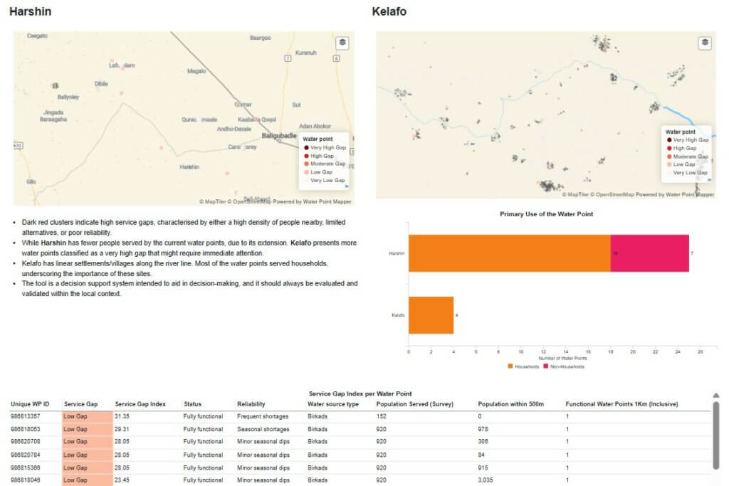
The goal of the Ethiopian Red Cross Society’s water mapping exercise was to strengthen climate resilience. By understanding where water points are within the Harshin and Kelafo districts of the Somali region, whether they work, and how vulnerable they are to hazards like droughts and floods, volunteers can select water points to prioritize for rehabilitation, upgrading, or water source protection. Having this information gives communities useful tools towards adapting to a changing climate and thriving in their environment.
“In Ethiopia, floods and droughts account for nearly 75% of all hazards, and both are driven by water-related risks. That’s why our work starts with communities: we help them understand the risks and own the actions needed to reduce impacts.”
Abraham Tesfaye, Anticipatory Action Focal Point at the Ethiopian Red Cross Society
From Paper Maps to Digital Dashboards
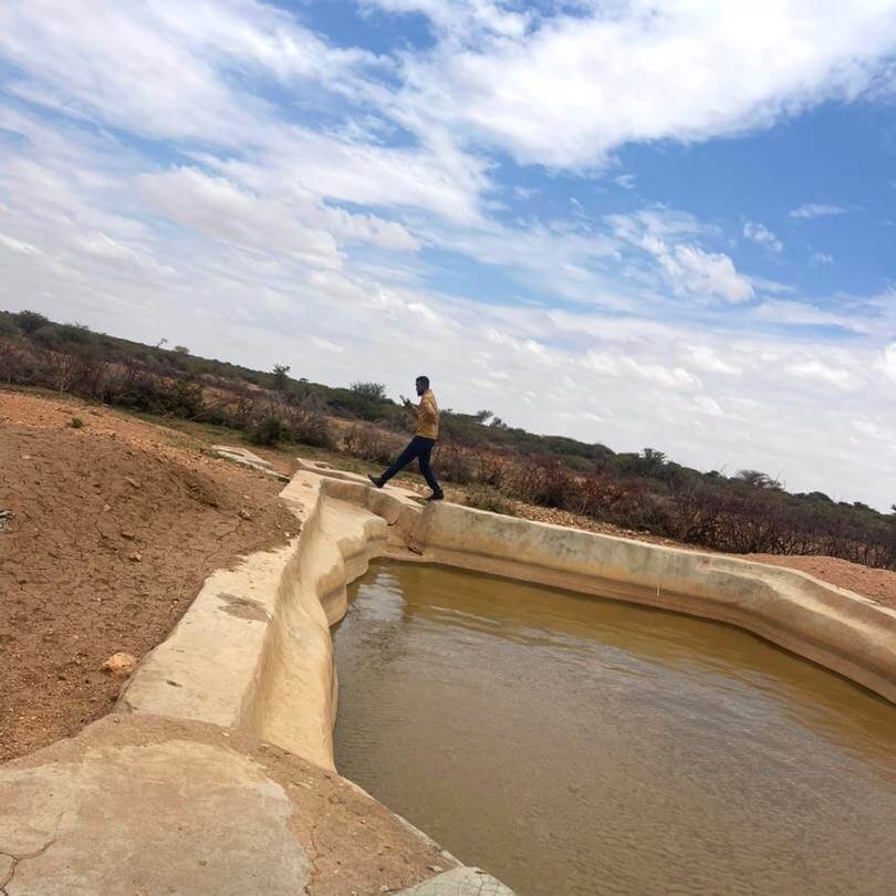
Traditionally, decisions about managing water infrastructure rely on fragmented information. This time, the Ethiopian Red Cross Society used mWater, a digital platform that helps collect and analyse WASH data and translates it into actionable insights. Volunteers fanned out across two districts, equipped with smartphones and trained by the Netherlands Red Cross on using mWater. They recorded the location and condition of each water point, assessed exposure to hazards, and uploaded everything into mWater.
“In Afdup, a town in Kelafo far from the river, people faced severe water shortages. By organizing as a community, they built their own water sources. Today, they not only meet their water needs but also exchange crops for water, proving that collective action can overcome the toughest challenges.”
Jamal Idris, volunteer at the Ethiopian Red Cross Society’s Kelafo branch
This data collection exercise has created a living map of water resources across Harshin and Kelafo, visualized on dashboards that the Ethiopian Red Cross Society can use to plan water point repairs, allocate resources, prepare for risks and monitor future interventions. The dashboards reveal service gaps, highlight vulnerable points, and guide decisions that could save lives through improved water access.
Technology made this possible, but people made it real. Ten volunteers spent days walking through communities, talking to residents, and collecting data to create an informative database that the Ethiopian Red Cross Society can use to guide preparedness activities. Their local knowledge ensured that mapping reflects reality, not just numbers.
“The integration of mWater has improved data quality, streamlined reporting processes, and provided real-time insights that support evidence-based decision-making. By making reliable information readily available, mWater has strengthened our capacity to identify risks early, monitor interventions effectively, and facilitate timely actions that enhance community climate resilience.”
Matebe Eshete, Emergency Operations Centre (EOC) Coordinator at the Ethiopian Red Cross Society
Looking ahead
Climate resilience starts with information. By knowing which water points are functional, and which are at risk, the Ethiopian Red Cross Society can plan interventions in a way that ensures optimal community preparedness for future disasters. And the benefits go beyond Ethiopia: any National Society can adopt this approach. With data management tools like mWater and the power of local actors, mapping water points becomes a practical, scalable way to strengthen resilience.
The Ethiopian Red Cross Society plans to integrate mWater into all water-related activities, building a centralized system for managing WASH infrastructure data. This will enable smarter decisions, equitable service delivery, and better preparedness for the climate challenges ahead. Because when the next drought or flood hits, communities won’t be asking “Where can we find safe water?” They already know.
DISCLAIMER: Please note that the Arabic, French and Spanish versions of this article were automatically generated using Artificial Intelligence. We cannot guarantee full accuracy of these versions.
We want to hear from you!
Are you interested in pursuing a similar solution with your National Society? Please reach out to:
Service Coordinator, Anticipatory Action: Aklilu Teklesadik ateklesadik@redcross.nl
Data and Information Management Coordinator: Wessel de Jong wdejong@redcross.nl
WASH Advisor: Sintayehu Gennoro sgennoro@redcross.nl